Minggu, September 30, 2007

Breaching Grounds - Raja Ampat

by Marthen Welly

The golden sky glimmers in the east, as the day dawns upon the stunning sphere of Raja Ampat. And it happened to be the dawn of an unforgettable adventure… an encounter with orcas at this heart of the world-renowned global coral triangle...

At first light, the monitoring team of The Nature Conservancy (TNC) was fully occupied with the various activities of checking and preparing the monitoring and diving gear, fueling the speedboat, checking engines, reviewing logistics and provisions, and checking navigation and communications equipment. On this day, the team is to carry out ecological monitoring routines on reef health and fish spawning aggregation sites around Misool, in the southern part of the Raja Ampat archipelago.

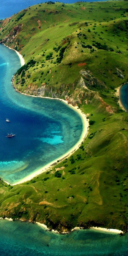
Within the hour everything was set, and Andreas Muljadi, leader of the monitoring team, passed the order to the speedboat captain to depart from Sorong harbor. The speedboat, named Fayam - "eagle ray" in the local Matbat language, cruised out to sea at a gradual speed, bringing the team to the area which is widely considered as the archipelago's 'Marine Mecca'.

The sky had turned to clear blue as the team reached the Dampier Strait, which is between the islands of Batanta and Waigeo. It was just eight o'clock. Several small islands started to come into view with their soft white sands and vivid, breathtaking coral surroundings. Andreas sat at the bow of Fayam, taking in all the joy of seafaring, while the other team members sat at the back of the vessel.

Suddenly Andreas saw a spout of seawater in the air in the distance... "Whale!" Andreas cried. The team members tried to figure out the whale's position. The captain slowly steered Fayam toward what seemed to be a pod of whales. As they approached, the engines were taken out of gear and silenced. Six whales came into view, swimming and playing in water.

Two whales curiously approached Fayam's starboard as the boat drifted to a stop while the other whales flapped their flukes in the water and jumped and spun their bodies. The two that approached Fayam were more inquisitive and seemed to observe the speedboat that carried the monitoring team. They swam and dove under the boat and emerged the other side.

The team was thrilled and very happy because this whale species that have come so close to them at this moment were orcas (Orcinus orca) - killer whales. These toothed whales are known to inhabit colder seas, grow up to over 7 meters long, have tall dorsal fins, and feed mainly on fish and squid. This species is uncommon in Indonesian waters. Orcas have a unique black and white color combination, making it very easy to recognize them - a sighting that caught us by surprise.

We didn't want to lose this incredible moment. Andreas grabbed his camera and took a number of photos. The other team members watched on uttering constant remarks about their physical appearance and behavior. They also made sure of recording the coordinates with Global Positioning System.

Raja Ampat's local community has frequently seen orcas around Kofiau-Boo Island. On several occasions they discovered orcas swimming off the beach at the front of their village. The locals call these visiting cetaceans rowetroyer and hold this intelligent sea mammal in high regard. If they come across an orca during fishing, they will head back to shore as a sign of respect for the orcas; they don't want to spoil the creatures' activities.

Time passed fast. For over an hour that the team observed the pod. It was then nine o'clock and the team continued on their trip to Misool.

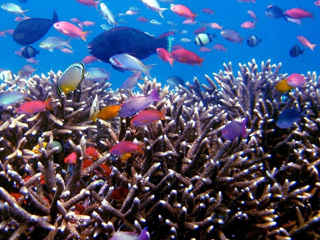
Upon arrival, they went to Haitlat Island which was the first site for monitoring reef health and fish populations. The team prepared their diving and monitoring gear and go ready. Monitoring is conducted at three depth levels; 4, 8 and 12 meters and is repeated five times at each level.
After three days of monitoring, the team finished data collection around the seas of Haitlat, Laitat, Masawan, Konawat, Senyu Besar, and Senyu Kecil Island and the coastal area of north and southeast Misool. On the fourth day, the team headed back to Sorong.

Tired from a long sea journey, the team members were back with big smiles on their faces, a sigh of relief from completing a successful mission, as well as the unforgettable experience of spending half of the journey with these incredible sea mammals. From the bottom of their hearts, they prayed for the protection of Raja Ampat's marine richness in which orcas find comfort during their seasonal ocean passing, and perhaps making its waters their 'home'.

fotografer : Adityo/TNC
source : http://www.baliandbeyond.co.id/archieves/archieve-frameset.htm

Derawan Islands: The Turtle Tale

by Marthen Welly

Derawan islands form a part of the global coral triangle, the paradise for three species of turtle: green, hawksbill and leatherback.

During nesting seasons, hundreds of sea turtles go out each night to lay eggs on soft, white, sandy beaches. Crystal clear water over a stretch of breathtaking corals and colorful fish tempts visitors to swim, snorkel or dive. Silhouettes of coconut trees and local fishermen on their wooden boats sailing off toward the sunset are an unforgettable draw of the idyllic Derawan Islands in East Kalimantan.

In the early mornings or late afternoons, one can easily find several adult sea turtles swimming not far from the beach or close to the jetties. Night divers in Derawan will be enthralled to catch sight of countless sea turtles sleeping around the reef.

Sea turtles are a Jurassic marine animal with a hard carapace to protect its soft body. Sea turtles now and again need to swim on the seawater surface to breathe. They feed on sea grass, small fishes and prawns. Turtles can swim thousands of miles during migration in certain seasons. Their eggs are tender and appear like a ping pong ball. Having a life expectancy of 30 years, sea turtles instinctively return to their nesting grounds on the same beach where they were born. An adult sea turtle has a diameter of about two meters and on average weighs around 300 kilograms.

Derawan Islands is an important nesting site for sea turtles in Southeast Asia. There are three kinds of sea turtles found around the Derawan Islands: the green, hawksbill and leatherback turtles. These islands, being part of the coral triangle, form the regionís largest nesting ground for the green sea turtles.

The Derawan Islands are located in the Berau district of East Kalimantan, the major islands being Derawan, Maratua, Samama, Panjang, Kakaban and Sangalaki. One can reach these islands from Surabaya, East Java or Jakarta with a stopover at Balikpapan and Tanjung Redeb, East Kalimantan. Derawan, Maratua, Kakaban, Samama and Sangalaki Islands all potential marine tourism areas can easily be accessed from Tanjung Redeb, the capital of the Berau district. A trip on a speed boat would take around three hours through the Segah River one may even catch a glimpse of the endangered freshwater Irawadi dolphins! Various types of accommodation are available on Derawan, Maratua and Sangalaki.

Kakaban Island is unique; at its center is a salt lake home to endemic brown-colored and transparent stingless jellyfishes. One can swim or snorkel in this lake, amidst thousands of these facsinating creatures. Diving sites around this island are amazing as well. Barracuda Point is one of the favorites. Over a hundred barracudas can be found in the waters here.

Another popular site near Sangalaki Island is Manta Ray Point. Sometimes, more than 50 rays (two-three meters in diameter) can be seen in a single sighting. Furthermore, Sangalaki Beach is one of the nesting sites for green turtles. Due to turtle egg poaching by people and also natural predators, there is an on-going effort to protect the eggs around the island. Some of these eggs are taken to a nursery and when they hatch, the baby turtles are released out to sea. Visitors can help set the baby turtles free, making it one of the Derawan’s highlights.

Panjang Island offers another interesting dive site. Strong currents and underwater caves make this site different from the others, and is recommended for advanced divers only. On the other hand, the sea around the islands is one of the migratory routes in Indonesia for whales and dolphins. If you are lucky, you can see more than a hundred whales and dolphins in several shoals. Research conducted by the conservation NGOs TNC-WWF joint program found that bottlenose dolphins and pilot whales are just a few of the cetaceans found in this area.

Coral reefs, important ecosystems for sea turtles and fish, face threats caused by human activities. These include the practice of destructive fishing methods such as bombs and cyanide, some types of nets, anchoring, and irresponsible divers and tourists during water activities. Damage to the reefs has caused the decrease in fish populations and fish, an important source of protein for people, are getting scarce.

The Berau local government and a number of NGOs have strived to restore the condition of the coral reefs. Recovery process can take decades due to the fact that corals grow only around three centimeters a year. The government has put measures to stop destructive fishing methods that will harm its coastal assets, especially turtles and coral reefs.

Derawan Islands is one of the priorities for marine conservation in Indonesia. The Berau local government, working together with a number of international and local NGOs, has declared a Marine Protected Area (MPA) protecting its marine and coastal areas, covering more than 1.27 million hectares to protect sea turtles and valuable coastal ecosystem. The local government is also eager to develop sustainable marine eco-tourism within this area and have encouraged the development of hostels, managed by the local people.

Today, more support is needed to protect the beautiful Derawan Islands with their underwater bounty. When some day we return to these memorable islands with our children and grandchildren, we want them to easily find the turtles nesting in peace.

fotografer : Anton Wijonarno/TNC
source : http://www.baliandbeyond.co.id/archieves/archieve-frameset.htm

Jumat, September 28, 2007

Paradise of Indonesia's Underwater

by Marthen Welly

The Wakatobi Islands are located in Southeast Sulawesi, and include the four main islands of Wanci, Kaledupa, Tomia and Binongko, with many other smaller islands as well. The majority of the residents in the Wakatobi Islands are from the Liya and Bajau tribes.

The Wakatobi Islands are known as one of the best diving sites in Indonesia, with spectacular coral gardens and a diverse range of fish. Since 1996, the Indonesia government under the Forestry Department has declared the Wakatobi Islands to be a National Park, with a total geographic area of 1.3 million hectares.

You can reach Wanci Island by sailing in a wooden boat for 12 hours from Kendari (the capital city of Southeast Sulawesi). Another alternative is to take a speed boat from Kendari to Bau-Bau in the Buton District (about 4 hours) and then continue using a wooden boat to get to Wanci (about 10 hours). All the exhaustion from your trip will disappear when you look out at the white sand on the beach, the coconut trees and crystal clear water, so clear that you can see the coral and fish right from the boat. In certain seasons, groups of whales and dolphins can be found in the waters around Wakatobi during their migration.

An island that is often visited by divers is Hoga Island. Hoga is small island located two miles off the northern part of Kaledupa Island. There is a resort on this island for tourism and research accommodations. Every year many students and researchers from around the world come to do research on coral, reef fish, and the marine ecosystem. There are several diving points on Hoga Island, and one of the most famous is the Outer Pinnacle around Hoga channel.

The first time diving at Outer Pinnacle point, you will find that the reef is around 10 meters deep, and that it looks like a zigzag dragon's back more than 500 meters long. Both sides of the spine have a drop-off contour with dark-blue seawater. At the end, in around 30 meters of water, there is tunnel about 5 meters long and you can swim inside and get all the way through to the other side. There is a diversity of coral and many big fish, such as the Napoleon wrasse (Chelinus undulates), groupers (Ephinephalus sp.), and snapper (Lutjanus sp.)

Kaledupa Reef is another interesting dive site in Wakatobi. The reef there is the longest reef-plat in Indonesia, stretching 6 kilometers between Kaledupa and Tomia Island. This reef is located 5 miles from the southern part of the Kaledupa and Tomia Islands. Sometimes you can find sea turtles (Chelonia midas) and manta rays (Manta birostris) around the Kaledupa reef.

Runduma is an island in the northern part of Wakatobi that is usually referred to as Turtle Island. During high season there are more than 20 turtles that come to the beach to lay their eggs. Unfortunately, many outside fishermen come to this island and poach the sea turtle eggs. Due to this island's location far away from the main island, it is difficult for the park rangers to control the poaching. The dive point on this island is the Anano reef. You can find a lot of sea fans there, with pygmy sea horses and anemones with clown fish as well.

Mari Mabuk "let's get drunk" at Tomia Island is a dive point that has strong currents and waves. This is natural since it is located in the open sea. It has the highest abundance of fish as based on a TNC-WWF joint program survey, and one of the spawning aggregation sites (SPAGs) for groupers.

The fairest island in Wakatobi is Binongko Island. The other name for it is Tukang Besi Island. This is because Binongko has a lot of iron workers (tukang besi). There are several diving points in this island, and the most well known are Kentiole and Koromaho, located in the eastern part. These diving points have drop off contours like a wall where you can find many reef sharks (black-tip).

There are a lot of interesting diving points in the Wakatobi Islands, one of the best places to dive in Indonesia and even in the Asia-Pacific region. Wakatobi Island is paradise for divers, and needs collaboration and strong effort to preserve this valuable asset for Indonesia.

sumber : http://www.baliandbeyond.co.id/archieves/archieve-frameset.htm

Jumat, September 21, 2007

Deklarasi 7 Kawasan Perlindungan Laut Raja Ampat

by Marthen Welly

Tim The Nature Conservancy (TNC) Raja Ampat bersama dengan mitra memfasilitasi Pemerintah Daerah Kabupaten Raja Ampat dan Dewan Adat Raja Ampat dalam deklarasi tujuh KPL baru di Raja Ampat. Ketujuh KPL di Raja Ampat tersebut meliputi Kofiau-Boo, Misool Timur Selatan, Waigeo Selatan, Teluk Mayalibit, Wayag, Sayang-Piai, dan Ayau, dengan total luas 654.000 hektar.

Dibentuknya jaringan KPL di Raja Ampat ini dengan tujuan untuk melestarikan stok ikan dan sumberdaya pesisir penting seperti terumbu karang, padang lamun dan mangrove. Jika sumberdaya tersebut dilestarikan, maka dapat memberikan manfaatnya secara terus-menerus bagi masyarakat Raja Ampat secara berkelanjutan. Ibarat sebuah bank, maka KPL dapat memberikan bunga dalam bentuk ikan-ikan baru secara terus-menerus bagi perairan sekitarnya sepanjang induk ikan dan tempat bertelur ikan tidak diganggu. Induk ikan diibaratkan sebagai modal pokok di bank.

Raja Ampat sendiri memiliki luas kurang lebih 4 juta hektar yang mencakup 12 Kecamatan dan 88 desa. Raja Ampat meliputi 610 pulau dengan 4 pulau utama yaitu Waigeo, Batanta, Salawati dan Misool. Kepulauan ini dikenal sebagai jantung segitiga karang dunia (Coral Triangle), berdasarkan kajian ilmiah ekologi secara cepat TNC (2002) dan Concervation International (2001), dengan melibatkan pada ahli biologi laut dunia, ditemukan sekitar 537 jenis karang dan 1074 jenis ikan. Hasil kajian tersebut membuktikan Raja Ampat sebagai kepulauan dengan keanekaragaman terumbu karang tertinggi di dunia, dimana jumlah jenis karang yang ditemui mencakup 75% jenis karang yang pernah diketahui di dunia.

Manfaat lain dari KPL jika dikelola secara efektif adalah keindahan panorama bawah laut dengan terumbu karang dan ikan yang berwarna-warni merupakan atraksi wisata bahari yang sangat menarik bagi para wisatawan untuk berenang, snorkeling atau menyelam. Karena bagusnya, saat ini banyak turis berkunjung ke Raja Ampat dengan menggunakan liveaboard atau menginap di resort yang ada di pulau Waigeo. Hal ini juga membawa manfaat bagi masyarakat Raja Ampat.

Akan tetapi, terumbu karang di Raja Ampat juga tak luput dari ancaman. Masih dijumpai nelayan dari luar Raja Ampat, datang menangkap ikan dengan menggunakan cara-cara yang merusak seperti bom dan sianida. Sebagai solusi terbaik yang ada saat ini, KPL merupakan salah satu metode untuk melindungi sumberdaya pesisir termasuk terumbu karang dari para perusak. Dalam KPL dibuat pembagian wilayah peruntukan yang biasa disebut zonasi, badan pengelola, patroli bersama, rencana pengelolaan dan pendanaan secara mandiri. Pengelolaannya sendiri dilakukan secara kolaborasi antara PemKab dan masyarakat Raja Ampat dengan didukung oleh LSM, akademisi dan sektor swasta.

fotografer : Marthen Welly
sumber : www.indonesiareef.com

Taman Nasional Komodo

by Marthen Welly

Taman Nasional Komodo selain terkenal dengan hewan purba-endemik Komodo (Varanus komodoensis), juga memiliki keanekaragaman hayati laut yang tinggi. Berdasarkan penelitian terbaru yang dilakukan oleh The Nature Conservancy (TNC), terdapat lebih dari 385 jenis karang penyusun terumbu, 1000 jenis ikan karang, 70 jenis sponge, 18 jenis paus dan lumba-lumba, pari-manta, dan penyu.

Disisi lain, hewan darat yang banyak dijumpai di TN Komodo yaitu rusa timor, burung gosong, burung kakak tua jambul kuning, kerbau liar, dan babi hutan. Karena keunikannya, sejak tahun 1991, TN Komodo dicanangkan sebagai Cagar Alam Warisan Dunia (World Heritage Site) oleh UNESCO.

Curah hujan yang sedikit, menjadikan TN Komodo sangat khas dengan padang savana dan bukit-bukit cadas berwarna coklat. Sangat kontras dengan kondisi perairannya yang jernih berwarna hijau kebiruan. Pemandangan menakjubkan ini merupakan surga bagi para wisatawan, photographer dan film-maker yang berkunjung kesana untuk menikmatinya dan berburu gambar-gambar eksotik selain komodo dan terumbu karang.

Terdapat tiga pulau utama di TN Komodo yaitu pulau Komodo, Rinca dan Padar selain puluhan pulau kecil disekitarnya. TN Komodo memiliki luas total 180.000 hektar, terdiri dari 60.000 hektar luas daratan dan 120.000 hektar luas perairan. Kurang lebih 3000 penduduk tinggal di empat desa yang terdapat didalam TN Komodo. Penduduk yang mayoritas berasal dari etnik bajo, bima, dan bugis tersebar di kampung Komodo, Rinca, Papagaran dan Kerora.

Bagi para pecinta dunia bawah laut, terdapat lebih dari 100 dive-site di TN Komodo, mulai dari yang berarus-tenang hingga yang berarus sangat kencang. Pantai merah di pulau Komodo yang biasa disebut dengan pink-beach oleh para turis mancanegara merupakan salah satu tempat terbaik untuk melakukan snorkeling dan penyelaman. Beberapa site penyelaman yang layak dicoba oleh para penyelam dengan kemahiran advance seperti batu bolong, karang makasar, gili lawa laut, gili lawa darat, crystal-rock, tatawa kecil, pulau indihang, padar, loh-sera dan batu tiga.

Saat ini Balai Taman Nasional Komodo (BTNK) sedang berproses menuju pengelolaan Taman Nasional secara kolaborasi dan mandiri secara pendanaan. PT. Putri Naga Komodo (PNK) merupakan mitra utama BTNK untuk menjalankan proses tersebut. Pendanaan secara mandiri dilakukan dengan mengelola dana sumbangan konservasi (conservation fund) yang dipungut dari setiap pengunjung dan sepenuhnya digunakan kembali untuk pengelolaan TN Komodo, termasuk upaya-upaya konservasi, kegiatan pariwisata alam, dan pemberdayaan masyarakat. Saat ini setiap tahunnya rata-rata 20.000 wisatawan datang berkunjung ke TN Komodo

fotografer : Marthen Welly/TNC
sumber : www.indonesiareef.com

Rabu, September 19, 2007

Taman Nasional Kepulauan Wakatobi

by Marthen Welly

Kepulauan Wakatobi terletak di Sulawesi Tenggara. Kata Wakatobi sendiri berasal dari dari 4 pulau utama yaitu Wanci, Kaledupa, Tomia dan Binongko. Terdapat puluhan pulau-pulau kecil lainnya disekitarnya. Mayoritas penduduk yang tinggal di kepulauan ini adalah suku Bajo dan Liya. Untuk berkunjung ke Wakatobi, diperlukan perjalanan kurang lebih 10 jam dengan menggunakan kapal penumpang dari Kendari menuju Wanci (ibukota Kabupaten Wakatobi). Alternatif lain adalah menggunakan kapal cepat kurang lebih 4 jam dari Kendari menuju Bau-Bau di pulau Buton dan dilanjutkan dengan kapal penumpang regular selama 6-8 jam menuju Wanci.

Kepulauan Wakatobi merupakan salah satu tempat penyelaman terbaik di Indonesia dengan keanekaragaman terumbu karang dan ikan yang tinggi (survey ilmiah FDC-IPB, 1994). Itu sebabnya mengapa pemerintah Indonesia, melalui Departemen Kehutanan menetapkan Kepulauan Wakatobi sebagai Taman Nasional pada tahun 1996 dengan total luas1,39 juta hektar. Hasil Rapid Ecological Assesment (REA) oleh program bersama kelautan TNC-WWF bekerjasama dengan Balai Taman Nasional Kepulauan Wakatobi menunjukan terdapat lebih dari 396 jenis karang dan 590 jenis ikan di Wakatobi.

Salah satu pulau yang sering dikunjungi para penyelam adalah pulau Hoga. Pulau Hoga merupakan pulau kecil di utara pulau Kaledupa. Di pulau ini telah dikembangkan resort wisata dan penelitian. Setiap tahun banyak mahasiswa dan peneliti dari luar negeri datang melakukan penelitian atau praktek kerja lapang terkait terumbu karang dan ekosistem laut lainnya. Terdapat beberapa site penyelaman di pulau Hoga ini. Salah satu site yang sangat menarik adalah outer-pinnacle di Hoga channel yang berbentuk seperti punggung naga dan terdapat terowongan diujungnya pada kedalaman sekitar 120 feet.

Beberapa site penyelaman yang menarik untuk dicoba seperti Wanci, Karang Kaledupa yang merupakan karang penghalang terpanjang di Indonesia, kurang lebih 6 km sebelah utara pulau Kaledupa dan Tomia, Karang Anano di pulau Runduma atau biasa disebut pulau penyu karena pulau ini memang merupakan habitat penyu bertelur, Mari Mabuk di pulau Tomia yang memiliki banyak ikan dan arus cukup kencang, serta Kentiole dan Koromaho di pulau Binongko yang juga dikenal sebagai pulau Tukang Besi. Mayoritas dive-spot di Wakatobi memiliki contour drop-off atau wall.

foto : Anton Wijonarno/TNC
sumber : www.indonesiareef.com

Selasa, September 18, 2007

Paus Pembunuh - Orca di Raja Ampat

by Marthen Welly

Tim monitoring TNC Raja Ampat untuk kedua kalinya bertemu Paus Pembunuh (Orcinus orca) di kepulauan Raja Ampat. Pertemuan tersebut sangat berkesan mengingat Orca sangat jarang terlihat di perairan Indonesia dan seumur hidup baru kali ini mereka melihat secara langsung di alam. Orca dapat ditemui di hampir semua lautan di dunia, akan tetapi kebanyakan Orca hidup di daerah dingin dan memiliki ciri khas warna hitam dan putih pada bagian badannya.

Meskipun namanya paus pembunuh, tetapi Orca ini sebenarnya adalah salah satu dari keluarga lumba-lumba (Delphinidae). Dengan panjang rata-rata tujuh meter, menjadikan Orca keluarga lumba-lumba terbesar di dunia. Nama paus pembunuh diberikan, karena Orca memakan berbagai jenis ikan besar , anjing laut, singa laut, hiu dan paus. Julukan lain dari Orca adalah srigala laut.

Pertemuan pertama tim monitoring TNC terjadi tahun lalu tanggal 13 Oktober 2006 di sekitar pulau Kofiau, bagian barat Raja Ampat. Enam Orca melintas di antara pulau Kofiau dan kampung Deer. Pertemuan kedua terjadi pada tanggal 8 April 2006 di sekitar selat Dampier antara pulau Waigeo dan Batanta. Kali ini hanya 2 ekor Orca saja yang terlihat.

Masyarakat Raja Ampat sendiri sering melihat Orca dan mereka menyebut Orca dengan sebutan Rowetroyer. Masyarakat Raja Ampat sangat menghormati mamalia laut yang memiliki kecerdasan cukup tinggi ini, jika mereka sedang menangkap ikan di laut dan bertemu Orca, mereka akan segera menghentikan kegiatannya dan menepi ke pantai agar Orca tidak terganggu.

foto : adityo/TNC
sumber : www.indonesiareef.com

Raja Ampat : Deklarasi 7 Kawasan Perlindungan Laut

by Marthen Welly

Tim The Nature Conservancy (TNC) Raja Ampat bersama dengan mitra memfasilitasi Pemerintah Daerah Kabupaten Raja Ampat dan Dewan Adat Raja Ampat dalam deklarasi tujuh KPL baru di Raja Ampat. Ketujuh KPL di Raja Ampat tersebut meliputi Kofiau-Boo, Misool Timur Selatan, Waigeo Selatan, Teluk Mayalibit, Wayag, Sayang-Piai, dan Ayau, dengan total luas 654.000 hektar.

Dibentuknya jaringan KPL di Raja Ampat ini dengan tujuan untuk melestarikan stok ikan dan sumberdaya pesisir penting seperti terumbu karang, padang lamun dan mangrove. Jika sumberdaya tersebut dilestarikan, maka dapat memberikan manfaatnya secara terus-menerus bagi masyarakat Raja Ampat secara berkelanjutan. Ibarat sebuah bank, maka KPL dapat memberikan bunga dalam bentuk ikan-ikan baru secara terus-menerus bagi perairan sekitarnya sepanjang induk ikan dan tempat bertelur ikan tidak diganggu. Induk ikan diibaratkan sebagai modal pokok di bank.

Raja Ampat sendiri memiliki luas kurang lebih 4 juta hektar yang mencakup 12 Kecamatan dan 88 desa. Raja Ampat meliputi 610 pulau dengan 4 pulau utama yaitu Waigeo, Batanta, Salawati dan Misool. Kepulauan ini dikenal sebagai jantung segitiga karang dunia (Coral Triangle), berdasarkan kajian ilmiah ekologi secara cepat TNC (2002) dan Concervation International (2001), dengan melibatkan pada ahli biologi laut dunia, ditemukan sekitar 537 jenis karang dan 1074 jenis ikan. Hasil kajian tersebut membuktikan Raja Ampat sebagai kepulauan dengan keanekaragaman terumbu karang tertinggi di dunia, dimana jumlah jenis karang yang ditemui mencakup 75% jenis karang yang pernah diketahui di dunia.

Manfaat lain dari KPL jika dikelola secara efektif adalah keindahan panorama bawah laut dengan terumbu karang dan ikan yang berwarna-warni merupakan atraksi wisata bahari yang sangat menarik bagi para wisatawan untuk berenang, snorkeling atau menyelam. Karena bagusnya, saat ini banyak turis berkunjung ke Raja Ampat dengan menggunakan liveaboard atau menginap di resort yang ada di pulau Waigeo. Hal ini juga membawa manfaat bagi masyarakat Raja Ampat.

Akan tetapi, terumbu karang di Raja Ampat juga tak luput dari ancaman. Masih dijumpai nelayan dari luar Raja Ampat, datang menangkap ikan dengan menggunakan cara-cara yang merusak seperti bom dan sianida. Sebagai solusi terbaik yang ada saat ini, KPL merupakan salah satu metode untuk melindungi sumberdaya pesisir termasuk terumbu karang dari para perusak. Dalam KPL dibuat pembagian wilayah peruntukan yang biasa disebut zonasi, badan pengelola, patroli bersama, rencana pengelolaan dan pendanaan secara mandiri.

Pengelolaannya sendiri dilakukan secara kolaborasi antara PemKab dan masyarakat Raja Ampat dengan didukung oleh LSM, akademisi dan sektor swasta.

foto : TNC-CTC
Sumber : http://www.indonesiareef.com/